Data Description
Landcover GAP2HA 1993 (raster)
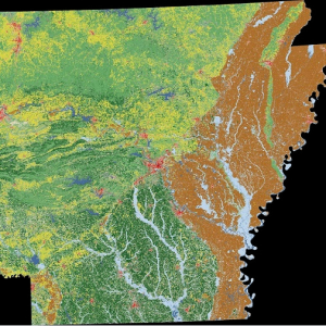
Data available online through GeoStor at http://www.geostor.arkansas.gov. This layer depicts 38 UNESCO/TNC based landcover categories for the State of Arkansas, which were derived from a digital classification of Landsat Thematic Mapper (TM) imagery, mostly from 1992, aggregated to a minimum mapping unit of 2 hectares. Categories: 1, T.1.A.9.b.I, Pinus echinata, shortleaf pine 2, T.1.A.9.b.II, Pinus taeda, loblolly pine 3, T.1.A.9.c.I, Juniperus virginiana, eastern red cedar 4, T.1.B.2.b.II, Quercus spp. – Pinus echinata – Carya spp., oak – shortleaf pine – hickory 5, T.1.B.2.b.III, Pinus taeda – Pinus echinata – Quercus spp., loblolly pine – shortleaf pine – oak 6, T.1.B.2.b.IV, Juniperus virginiana, eastern red cedar 7, T.1.B.3.a.I, Fagus grandifolia, american beech 8, T.1.B.3.a.II, Quercus alba, white oak – mixed hardwoods 9, T.1.B.3.a.III, Quercus rubra – Quercus spp., northern red oak – oak 10, T.1.B.3.a.IV, Quercus falcata – Quercus spp., southern red oak – oak 11, T.1.B.3.a.V, Quercus stellata, post oak 12, T.2.A.2.b.I, Juniperus virginiana – Quercus spp., eastern red cedar – oak 13, T.2.B.3.a.I, Pinus echinata – Quercus spp., shortleaf pine – oak 14, T.2.B.3.a.II, Juniperus ashei – Quercus spp., white cedar – oak 15, T.2.B.4.a.I, Quercus spp. – Carya texana, oak – black hickory 16, T.4.B.3.a.II, Mixed shrub species, mixed shrub 17, T.5.A.1.a.I, Mesic Prairie, tall mesic prairie 18, P.1.B.3.c.I, Quercus lyrata, overcup oak 19, P.1.B.3.c.II, Carya aquatica, water hickory 20, P.1.B.3.c.III, Quercus falcata var. pagodifolia, cherrybark oak 21, P.1.B.3.c.IV, Celtis laevigata, sugarberry 22, P.1.B.3.c.V, Quercus nuttallii, nutall oak 23, P.1.B.3.c.VII, Quercus phellos, willow oak 24, P.1.B.3.c.VIII, Liquidambar styraciflua, sweetgum 25, P.1.B.3.d.I, Taxodium distichum, baldcypress – mixed hardwoods 26, P.1.B.3.d.I.1.a., Taxodium distichum, baldcypress 27, P.1.B.3.d.II, Nyssa, tupelo – gum 28, P.5.A.4.a.I, Tall grass, tall prairie (moist to wet) 29, P.5.A.4.b.III, Arundinaria gigantea, tall prairie (disturbed) 30, R.1.B.3.c.I, Salix – Populus, willow – cottonwood 31, R.1.B.3.c.II, Betula – Platanus – Acer, birch – sycamore – maple 32, R.6.A.1.a.I, Bare, bare 33, W, Water, water 34, AGW, Agriculture, Agricluture (wet crops) 35, AGD, Agriculture, Agriculture (dry crops) 36, AGP, Agriculture, Agriculture (pasture) 37, URC, Urban, Urban Commercial-Industrial 38, URR, Urban, Urban Residential
[Keywords: imageryBaseMapsEarthcover land use cover lulc ]

